It had been nearly five months since I'd been in the mountains. Far too long. So with a free Saturday over Memorial Day weekend, I grabbed the dog and headed for the House Mountain Preserve near Lexington, VA to continue my quest to climb the 50 most prominent peaks in the southeastern U.S.
Left the house at 5:30 in the morning, and arrived at the House Mountain trail head at about 9am, where my peakbagging pal Rick Shortt was waiting for us. There's a designated area for parking, as private property surrounds the preserve. We headed up right away, following an old jeep road through the woods at a pretty steep clip until reaching the grassy saddle between Big and Little House (3645' and 3380', respectively). A sign is there that gives a history of the area and honors Bill Stubbs for his tireless conservation efforts in Rockbridge County.
 |
Gus at the House Mountain saddle, blissfully
unaware of the ticks crawling up his legs |
 |
| Bill Stubbs memorial |
From the saddle we headed right via an unmarked trail through tall grass. It immediately transitioned to a STEEEP, rocky ass-kicker. The unseasonably cool 70 degrees felt like 90 by the time we reached the summit ridge. Rick's legs are often indistinguishable from the tree trunks surrounding the trail and he keeps a relenting, fast pace.
 |
| Nice rock arch on the trail up Little House Mountain |
 |
| Gus struggled a bit with the boulders |
We peakbaggers are an obsessive lot, and need to be certain we've hit the highest point to claim a summit. For Little House mountain there are two elevation contours on the map that contend for the highest spot on the mountain, so both must be explored. To reach the first it's a short detour through thick mountain laurel, but nearby cliffs offer nice views of the surroundings. The second area is likely the summit, and it's a rare treat for our mountains down here - a 15 foot vertical scramble. Rick found a nice crack system to climb - I was slower to follow with the crappy grip on my running shoes. I'm a slow learner - this is at least the fourth time I've regretted wearing them on a hike. You could call it class 3 or 4 - I've heard the rule that if a dog can do it, it's class 3...Gus refused to join us, whining at the base of the rock formation. But he's also a wimp, so we'll call it 3+. Getting down was trickier, requiring a firm handhold deep in the crack to support the downclimb. Got our attention!
 |
| Rick climbing the Little House summit block |
 |
| Me climbing the summit block. The confused look on my visage is status quo. Photo by Rick Shortt |
The Little House trail continues for another quarter mile or so, which took us to a stunning vantage point. Nice views of a Big Butt...Mountain.
 |
| Do these trees make my Butt look Big? Yes, yes, they do. |
After taking in the views from the vantage point, we headed to the main objective of the day, Big House Mountain. Back down to the saddle we went, and hiked a more reasonable, well-trodden trail. First stop was another nice vantage point with some nice outcrops. We hung out there for a bit, hiked to the summit with its ugly old stone structure and then past it for about 3/4 of a mile to another great vantage point.
 |
| Rick taking in the views from Big House |
 |
| Gus happy to have another summit under his belt |
The return to the car was pretty uneventful. Total mileage for this one was 9.8 miles with about 3400' of elevation gain. Took us about 6 hours with all of the breaks.
At this point, Rick headed back home, and Gus and I headed for one more peak - one of the seven bajillion Brushy Mountains in the Southeast. This one has over 1000' of prominence and an elevation of nearly 3600', and since we were in the area...
Gus and I drove about 30 minutes to the trailhead in the Rich Hole Wilderness (the official geographer in these parts obviously had a great sense of humor). Being in a wilderness, no trail markings are usually found. The trail wasn't well marked either, and after about a mile it completely petered out.
 |
| This is a trail? |
From there it was a steep climb through pretty easy vegetation to the summit ridge. Gus was seriously doubting my navigational skills, but we made it to the ridge, weaving our way around some neat rock fins (stay to the right/north to avoid getting cliffed out).
 |
| Some of the rock fins along the Brushy Mountain summit ridge. |
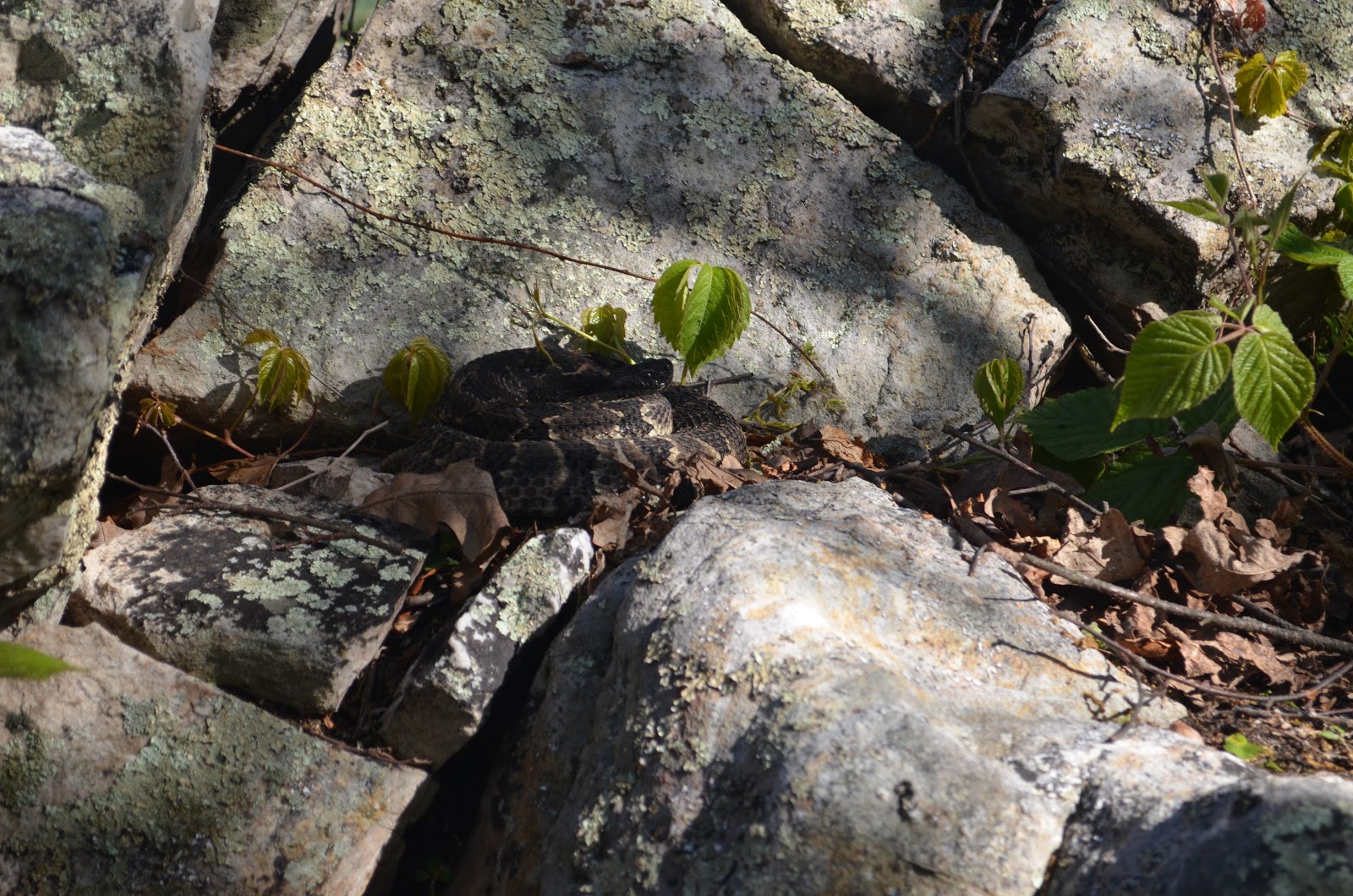
Finally reaching the summit area, I quickly took a few steps up some rocks to touch the tippy top of the highest point as is the usual silly peakbagging custom. I heard something strange below me, instinctively moved back, and saw a rattlesnake coiled up on the ground next to me! I'm still not sure if I heard a rattle, but I quickly retreated, held my dog's collar to keep him out of trouble, and snapped a couple of pictures. Before I heard the snake my left foot couldn't have been more than a few inches from it and I didn't even see it! I'm lucky it was cold for May..
 |
| The Brushy Mountain denizen. Hard to see at first... |
 |
| Another shot of the snake. I was reaching for the high point in the picture when I spotted him. |
Gus and I headed back down to the car, making it there uneventfully. The Brushy Mtn hike was 3.2 miles with about 1150' elevation gain, giving us a respectable 13 mile, 4500' eg day. This earned Gus a couple cheeseburgers (and me the pleasure of smelling dog flatulence) on the way home.
 |
| The spoils of a nice day in the mountains. |
 |
| Big and Little House Mountain |
Directions, etc:
Big/Little House
From Lexington, VA, head west on US-60 for a couple of miles. Turn left onto VA-641 (Jacktown Road) and proceed 3.4 miles. Turn right onto VA-643 (Saddle Ridge Road) and follow the road until you reach signs for hiker parking at 37.81156° N, 79.53239° W. The trail follows a road for the first bit (essentially a continuation of Saddle Ridge Road). Follow this, gaining elevation, until reaching the saddle between Big and Little House (37.82830° N, 79.55349° W). For Little House, follow a trail going right (east). It will soon fork; take the right fork and follow to the top. This trail has blue blazes on it and is pretty steep. You'll pass through a small boulder field on the way to the top. Once you reach the summit ridge, follow the trail. The first contour (37.82721° N, 79.54753° W) is off to the left in a thicket of mountain laurel. Roam around until you find the high ground (you can continue in this direction to some cliffs for good views of Big House). Return to the trail and continue. You'll come to the summit block (I don't have exact coordinates as my GPS ran out of batteries, but the map gives it as 37.82926° N, 79.54360° W. The face closest to the trail offers the easiest access to the top. Climb up a ledge about 6' off the ground, then work your way up the crack. Be sure to find the bomber hand-holder Rick found on the way up; you'll need it for support on the downclimb. After getting up and down, one can head back to the saddle or continue along the trail to a nice viewpoint. To get Big House from the saddle, take the more well-traveled path to the left and follow to the summit. There's a short side trip to some great views near the last switchback below the top - continue straight instead of turning, and you'll soon be among some rock outcrops with nice views to the north and west. The summit is along the trail and marked by an ugly stone structure.
Brushy Mountain (the one on the border of Rockbridge and Alleghany counties)
To reach Brushy Mountain from the House Mtn areas, get back on US-60 and head west until reaching I-64 in a few miles. Go west 7 miles on I-64, taking exit 43 for VA-780 (Goshen). Turn right onto 780 and after a quarter mile turn left onto VA-850/VA-780 (signed as W Midland Trail). Continue to follow VA-850/W Midland Trail for 2.6 miles, where you'll reach a turnout in the road with a wood post marked "13." This is the Rich Hole trailhead (37.86988° N, 79.62507° W). Head up the trail, passing a registration kiosk. When I was there, the trail was overgrown and hard to follow in places. The map shows that the trail goes over the shoulder of Brushy Mountain, but I completely lost the trail at the first saddle (37.87313° N, 79.63429° W) and just bushwhacked straight up the ridge. At the top of this bushwhack, turn left and follow the ridge to the summit (37.87147° N, 79.64134° W). Round trip for this one is 3.2 miles with 1150' of elevation gain.